10 Most Beautiful Places on Route 66
What are the Most Beautiful Sites on Route 66?
Stopping at the most beautiful sites along Route 66 was a highlight for travellers during the road’s heyday. While it no longer officially exists as a USA highway, many of its iconic stop-offs remain, including a diverse array of breathtaking natural wonders and historic landmarks.
You can visit stunning state parks with some of the country’s most scenic hiking, drive through the awe-inspiring Petrified Forest and see the iconic structures and engineering marvels that make Route 66 legendary. Check out our round-up of the most beautiful sites along Route 66 and start planning your trip.
1. Grant Park, Chicago, Illinois
Starting point of Route 66

Categorías: Historia, Fotos, Asequible
Grant Park, Chicago, Illinois, is a vast urban park sandwiched between the shores of Lake Michigan and the Chicago downtown skyscrapers. Route 66 originally started at the corner of Jackson Boulevard and Michigan Avenue, right next to Grant Park. This historic green space is now home to iconic landmarks, striking gardens and cultural institutions.
A key attraction is Buckingham Fountain, one of the world’s largest, with hourly water shows and nighttime light and musical displays. Visit early morning or evening to avoid crowds and capture the best lighting for the fountain and nearby Cloud Gate in the Millennium Park section. Check the park’s schedule for major events like the Lollapalooza Music Festival and smaller concerts and festivals.
Horario: Daily from 6 am to 11 pm

Grant Park, Chicago, Illinois
2. Old Chain of Rocks Bridge, Illinois and Missouri
Historic bridge on Route 66 connecting Illinois and Missouri
Categorías: Fotos, Poco común
Route 66 crosses the Mississippi River from Illinois to Missouri at the Old Chain of Rocks Bridge. Built in 1929, this bridge was a vital connection for travellers on the Mother Road. Today the bridge is beautifully maintained with its distinctive 22-degree bend and remains one of the highway’s most famous landmarks.
Now open to pedestrians and cyclists only, its 1.6-km span across the Mississippi is a scenic route passing the river’s 2 water tower buildings with beautiful views of the natural surroundings and the St. Louis skyline beyond. You have to walk it during the day as the bridge is locked at sunset and you can only park on the Illinois side.
Dirección: 10820 Riverview Dr, St. Louis, MO 63137, USA
Horario: Daily from 9 am to 8.30 pm
Old Chain of Rocks Bridge, Illinois and Missouri
3. Gateway Arch, St. Louis, Missouri
Tallest manufactured monument in the USA
Categorías: Fotos, Poco común, Historia
Gateway Arch in St. Louis, Missouri, is a symbol of the western expansion of the United States and one of the most iconic monuments on Route 66. This gravity-defying, 192-m structure is a catenary arch, an engineering and architectural wonder, representing a gateway to the future and the spirit of exploration and innovation. It remains the tallest constructed monument in the USA.
You can ride the tram system to the top of the arch for views across St. Louis and the Mississippi. The Museum at the base of the arch explores the history of westward expansion, the Lewis and Clark expedition and the role St. Louis played in this era.
Horario: Daily from 5 am to 11 pm
Gateway Arch, St. Louis, Missouri
4. Painted desert in the Petrified Forest, Arizona
Route 66 runs through this mesmerizing national park
Categorías: Aventuras, Fotos, Poco común
The Painted Desert is a natural landscape in the Petrified Forest National Park with compelling geological formations. You can drive through 35 km of the incredible painted desert Badlands. It’s the only National Park in the country with a portion of Route 66 running right through it.
You’ll see ancient, fossilized trees from the Late Triassic period when the terrain was a lush tropical forest, and the colourful Chinle Formation, consisting of mudstone and sandstone rocks deposited between 227 and 205 million years ago when supercontinent Pangaea existed. As you drive through, stop at the scenic viewpoints and take some of the short hiking trails for a closeup look at the dramatic scenery.
Dirección: Petrified Forest National Park, AZ 86028, USA
Horario: Daily from 8 am to 5 pm
Painted desert in the Petrified Forest, Arizona
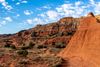
5. Canyon in the Palo Duro Canyon State Park, Texas
Second largest canyon in the United States
Categorías: Aventuras, Fotos
Palo Duro Canyon in the Palo Duro Canyon State Park in Texas is the second largest canyon in the USA. Over 48 km of hiking trails wind through it, including the Lighthouse Trail, a 10-km hike to its famous rock spire. You may see deer, bush turkeys, roadrunners and male collard lizards (they’re a spectacular iridescent green), while birdwatchers can spot hawks and golden eagles. During summer, the popular Texas Outdoor Musical tells the story of Texas settlers in the natural amphitheatre.
Spring and fall are the best times to visit for mild outdoor temperatures. Hikers should start early to avoid heat and crowds, especially in summer, and take lots of water as the Texas heat can be intense.
Horario: Daily from 7 am to 9 pm
Teléfono: +1 806-488-2227
Canyon in the Palo Duro Canyon State Park, Texas
6. Rainbow Bridge, Riverton, Kansas
Original bridge on Route 66
Categorías: Historia, Asequible
Rainbow Bridge, in Riverton, Kansas, was built in 1923 and is the only remaining marsh arch bridge on Route 66. Officially called the Brush Creek Bridge, the Rainbow Bridge is an example of a concrete marsh arch bridge, with a gracefully curved arch design. It’s not especially large, but it remains popular with Route 66 enthusiasts as one the original parts of the highway.
Added to the National Register of Historic Places in 1983, it’s a nostalgic and worthwhile detour. While you’re there visit the 2 charming towns nearby along Route 66, Riverton and Baxter Springs, and the Old Riverton Store, a historic shop that has served Route 66 travellers since the 1920s.
Dirección: Rainbow Bridge, SE Beasley Rd, Baxter Springs, KS 66713, USA
Rainbow Bridge, Riverton, Kansas
7. Quartz Mountain State Park, Oklahoma
Rugged state park with hiking, wildlife and lake fishing
Categorías: Familias, Parejas, Aventuras
Quartz Mountain State Park in southwestern Oklahoma is a natural area of rugged terrain with dramatic cliffs and unique rock formations. It’s tranquil and uncrowded, with only basic camping facilities and limited dining options, so it’s ideal for a nature escape. A major attraction is Lake Altus-Lugert, known for its sandy beach, kayaking and fishing for bass and catfish.
The park has a variety of hiking trails, both easy and challenging, with good wildlife and bird-watching opportunities. The best times to visit are during the spring wildflower bloom and in the fall with its cooler weather and vibrant foliage. Try to visit at dusk when the colours over the rugged landscape are magical.
Dirección: 14722 OK-44A, Lone Wolf, OK 73655, USA
Horario: Daily from 8 am to 4.30 pm
Teléfono: +1 580-563-2238
Quartz Mountain State Park, Oklahoma
8. Sandia Crest, New Mexico
Mountain peak with aerial tramway
Categorías: Aventuras, Fotos
Sandia Crest, just outside Albuquerque, is the highest peak in the Sandia Mountains, with panoramic views of the Rio Grande Valley. A scenic road winds from the foothills to the summit, with access to hiking trails along the way. This route is also popular with cyclists seeking a challenging ascent.
You can also reach the summit on the Sandia Peak Aerial Tramway from Albuquerque, a 15-minute ride over canyons and forests. In summer, Sandia Crest is a cool escape for hikers, while in winter the popular ski resort opens with mostly beginner and intermediate slopes. Sandia Crest is a prime spot for birdwatchers because 3 species of rare rosy finches migrate there from November to March.
Sandia Crest, New Mexico
9. Bluewater Lake State Park, New Mexico
A high-desert landscape and lake near Route 66
Categorías: Aventuras, Fotos, Familias
Bluewater Lake State Park, New Mexico, is a popular spot for fishing, camping and outdoor recreation. Located at an elevation of 2,250 m in the Zuni Mountains, it offers cool summer temperatures and the chance to see wild horses drinking from the lake. Anglers can fish for trout and giant tiger muskie (with a bag limit of one per angler) or hike the rugged terrain.
In winter, the park is known for ice fishing and campsites remain open in the picturesque snowy landscape. There is no cell phone service in the park so use it as a chance to reconnect with nature. Explore the nostalgic Route 66 ruins in the nearby town of Bluewater.
Dirección: 30 Bluewater State Park Road, Prewitt, NM 87045, USA
Horario: Daily from 7 am to 9 pm
Teléfono: +1 505-876-2391
Bluewater Lake State Park, New Mexico
10. Santa Monica Beach, Santa Monica, California
The end of Route 66
Categorías: Aventuras, Fotos, Asequible
Santa Monica Beach, California, marks the western terminus of Route 66. America’s historic highway traversed 4,000 km across a variety of landscapes from Chicago to the Pacific Coast and was a symbol of freedom, adventure and prosperity ahead. Reaching Santa Monica Beach represented the completion of the journey.
Santa Monica Beach, with its vast sandy expanse, warm water and Santa Monica Pier, was a great spot to celebrate the achievement with its amusement park, historic carousel, lively restaurants, street performers and sweeping views of the Pacific. Try to visit on weekdays to avoid the weekend crowds, especially during peak summer months.
Santa Monica Beach, Santa Monica, California
En este artículo se incluyen las opiniones del equipo editorial de Go Guides. Los autores de este tipo de artículos reciben una compensación por parte de Hoteles.com, que puede abarcar desde viajes hasta cualquier otro tipo de costes.